(
(Wms2Cad
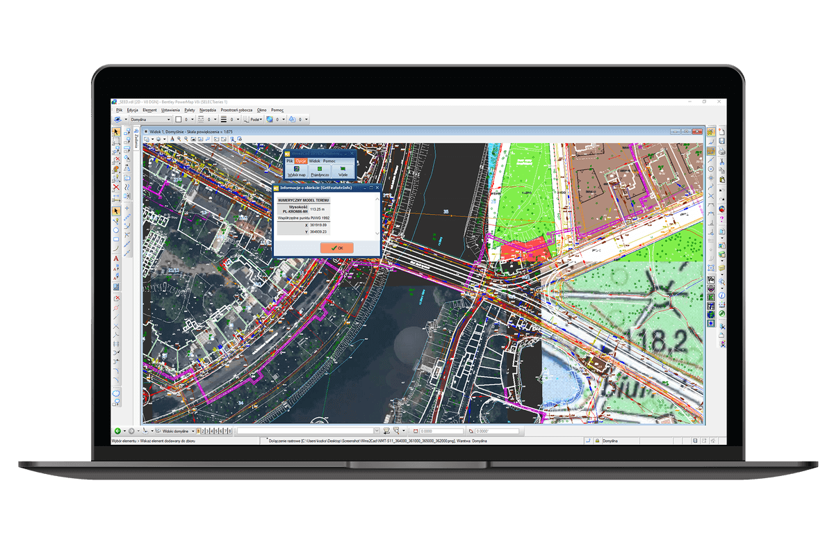
Wms2Cad allows you to quickly and conveniently download and view maps and imagery from WMS services in CAD. The built-in list of WMS, WMTS and TMS services will allow you to instantly download maps from the most popular services (e.g. Geoportal, Google Earth, Google Maps). You can also easily add other WMS services. Wms2Cad also allows you to acquire additional information from these services like ordinates from NMT (numerical terrain model).
Buy Wms2Cad
Buy a license and start using the program today!
Choose the variant that suits your needs:
Stationary licenses

(1 seat)
period:annual
(1 seat)
period:perpetual
Remote licenses
(USB remote)
period:annual
(USB remote)
period:perpetual
Update and support
(1 seat)
period:annual
(1 seat)
period:annual
Buy a license and start using the program today! Choose the variant suitable for your needs! A single-station license will allow you to use the program on one device, while a portable (USB) license will allow you to work with the program on multiple stations (devices). Effectively adjust your purchase to the expected duration of program use with one of the additional options (perpetual and temporary keys). Learn more about the licenses.
Wms2Cad
0,00 $
Selected product
Wms2Cad
Total
0,00 $
Available payment methods

Features of the program
- extremely easy to display images from WMS services in CAD (with one click or area selection)
- display one or many tiles
- Expressly display multiple high-level tiles with support for WMTS services
- Expressly display multiple high-level tiles with support for WMTS services
- display a lot of information about the site (including elevation from NMT at the indicated point, parcel registration data, structure, soil type and water table from a detailed geological map)
- very conveniently display tiles from the most popular map services (including maps from Geoportal, maps from Open Street Map, base map and mpzp)
- display tiles from any WMS service (if the service owner has made the address public)
- orthophotomap
- local development plans
- base map
- registration map
- numerical terrain model
- roadmaps
- topographic map
- forest maps
- tourist maps
- map of the General Directorate for Environmental Protection
- and many other thematic maps.
Please note that the data provided by map services may be protected by law.In order to make practical use of the data displayed thanks to Wms2Cad, you may be required to obtain permission from the owner of the selected service.
Try for free!
10-day trial period
Customer reviews
Geoopus
Bogumił Mierzejewski
Wms2Cad an unprecedentedly simple program that helps to find the measurement in the field and to plant the map from the servers.
Wrocław, dolnośląskie
Promar
Marcin Rybakiewicz
“The downloading of WMS from Geoportal is done without any problems.”
Przecław, zachodniopomorskie
Zatorski GmbH
Wms2Cad makes downloading the maps from the servers exceptionally easy.
Wms2Cad macht es besonders einfach, die Karten von den Servern zu unterlegen.
Alteglofsheim, DE
GLOBAL Geo Services
Krzysztof Beczkowski
“Fast display of WMS and WMTS map services. Big plus for the ability to display object information.”
Bezrzecze, zachodniopomorskie
Szoka projekt elektroenergetyka,
Mateusz Szoka – projektant/właściciel
“A few clicks and the orthophotomap jumps into the right coordinates, which speeds up the work a lot.”
Ostrołęka, mazowieckie
Droga Development
Michał Góralski
“In our opinion, the Wms2Cad and Geoview programs are an absolute must-have for any road design office.”
Lublin, lubelskie