(
(RawGNSS
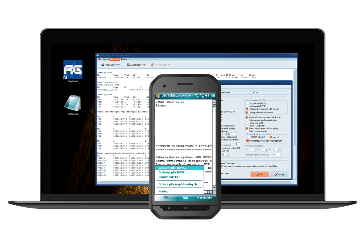
RawGNSS is an easy-to-use software to generate editable reports from GNSS measurements, basing on RAW / RW5, Land XML, Job XML (JXL) and CSV files. It has many tools to create personalized measurement reports, including averaged coordinates from multiple measurements or comparisons from control measurements.
Buy RawGNSS
Buy a license and start using the program today!
Choose a variant suitable for your needs:
Stationary licenses

(1 seat)
period:annual
Remote licenses
(USB remote)
period:annual
Buy a license and start using the program today! Choose the variant suitable for your needs! A single-station license will allow you to use the program on one device, while a portable (USB) license will allow you to work with the program on multiple stations (devices). Effectively adjust your purchase to the expected duration of program use with one of the additional options (perpetual and temporary keys). Learn more about the licenses.
RawGNSS
0,00 $
Selected product
RawGNSS
Total
0,00 $
Available payment methods

Features of the program
- report generated as a text file or HTML table
- possibility to adjust the content and form of the report to individual needs
- tools for automatic generation of average points, calculation of differences from control measurements and quality control of measurements
- semi-automatic correction of incorrectly entered antenna height along with conversion of point elevations
- works on PCs as well as on Windows Mobile and Android devices (built into QuickGNSS).
- RTN/RTK Measurement Reports
Optimized to create RTN/RTK survey reports for survey documentation centers - The generated report complies with draft G-1.12 guidelines
- Customization of the report to the required specification. Thanks to additional parameters, the report can be easily adapted to the specific requirements of the facility or the user’s needs.
- View of the report
The appearance of the report can be customized to suit your needs by creating report templates. It is also possible to generate a “traditional” text report or a report formatted with tables (HTML).
- Generating a report
The report can be generated from any RAW and RW5 file compatible with the TDS (Tripod Data Systems) standard and from a CSV file generated from the LandStar software. - SurvCE specific file support
LOC, SYS, INF, CRD. - Cooperation with programs
Tested with source files from: Survey Pro, TopSurv, Field Genius, SurvCE, FASTSurvey, LandStar, X-PAD.
- averaging multiple measurements
- list of control measurement points
- point quality check
- location report
- handling of points measured by indirect methods
- possibility to correct incorrectly entered pole heights
- Runs on Windows Mobile
For operating systems installed on the controller to support GNSS receivers - Can run as a C-GEO plugin
Allows you to easily save coordinates to the working table and save the report directly in the C-GEO report module. - Display result coordinates
The resulting coordinates can be displayed in Google Earth, displayed or further processed in our GeoView application or saved to a text file together with location and elevation errors. - Export of vectors and base stations
Ability to export vectors and base stations to the alignment module in Winkalk - Printing and saving the report
The received report can be printed or saved to a text or HTML file, or added to C-GEO reports, if RawGenius works as a plugin.
Try for free!
10 day trial period
Customer reviews
GEOPOINT
Jacek Walczak
RawGNSS is a well-developed program, the ability to directly save texts and generate individual reports
Olesno, Opolskie
Przedsiębiorstwo Geodezyjne “GEOSIT”
Tomasz Placha
RawGNSS together with QuickGNSS make a great duo, thanks to which taking measurements and reports is pure pleasure.
Busko – Zdrój
Geocel
Maciej Woźny
Although reports are no longer required, I still use RawGNSS, I can very quickly correct a wrongly entered pole height or analyze the correctness of the measurement.
Wrocław, dolnośląskie
Geo-Plan
Rafał Burda Cienin
Many interesting functions to help you create GNSS reports.
Kościelny, wielkopolskie