(
(QuickGNSS
Drive your field survey to the next level!
QuickGNSS is our revolutionary data collection software. It allows you to do field survey (both measure and stake) with GNSS (GPS) technology on any device with Android. You can use QuickGNSS together with many popular GNSS receivers and other devices with GNSS functionality, like mobile phones or tablets.
Buy a license and start using the program today!
Choose the variant that suits your needs:
Stationary licenses

(1 seat)
period:annual
(1 seat)
period:perpetual
Update and support
(1 seat)
period:annual
Buy a license and start using the program today! Choose the variant suitable for your needs! A single-station license will allow you to use the program on one device, while a portable (USB) license will allow you to work with the program on multiple stations (devices). Effectively adjust your purchase to the expected duration of program use with one of the additional options (perpetual and temporary keys). Learn more about the licenses.
QuickGNSS
0,00 $
Selected product
QuickGNSS
Total
0,00 $
Available payment methods

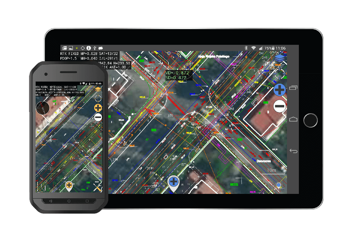
FEATURES OF THE PROGRAM
- save – no need to buy a controller, QuickGNSS works on any Android smartphone
- don’t waste time on training – intuitiveness is a QuickGNSS trademark
you measure as easily as never before! – the program is very user-friendly - works with your receiver – adapted to receivers from various manufacturers, including inclinometer receivers
- measure more efficiently – thanks to a higher epoch measurement frequency than 1 second
- you work efficiently on large dxf files – thanks to an efficient graphics engine
- generate measurement reports – thanks to an advanced reporting tool
- stake out almost anything – thanks to the many options for staking out from a vector map
you work with sonar and laser rangefinder – QuickGNSS supports these devices via Bluetooth - you can easily measure the most complex objects – thanks to point management tools (e.g. antenna height correction, assigning photos and recordings, displaying in Google Maps)
- you can easily exchange data between the office and the field – using the CubicCloud cloud or other services in Android (with the RawGNSS)
- it’s easier to find your way around – thanks to the option of using WMS and WMTS services as the map background
If QuickGNSS does not work on your receiver, please contact. We will be happy to adapt our application to your receiver. In exchange for sending us a receiver for QuickGNSS, you will receive a free one-year license for QuickGNSS!
- Support for virtually all coordinate systemsBoth available in Poland and worldwide. Possibility to perform adaptation to the local layout
- Support for various geoid models
- Inclinometer operation
- Possibility to use the GPS receiver built into the device
There is no need to use an external antenna. - Support for sonar and laser rangefinders
Applies to models with a Bluetooth connection. - Automatically connect devices at program startup
Including receiver. - Generate reports
Built-in tool for generating survey reports directly from the QuickGNSS menu. - Support multiple dxf files
With the ability to turn them on and off for display - Import and export of data
Ability to import and export data from/to Cubic Cloud, between QuickGNSS and other CubicOrb programs - Easy editing of measured points
Including correcting the height of the antenna and assigning photos and recordings to individual points. - Smart compass
Using the device’s built-in magnetometer and gyroscope; after exceeding the set distance during stakeout, switching to precision stakeout mode - Current parameter view
Solution parameters, coordinates and basic measurement and stakeout settings - Advanced tool for WMS services
Wizard for adding any websites, the ability to display several websites at the same time, built-in list of predefined most popular websites - Calculation Tools
e.g. distance, angle, area, etc. - A range of tools for advanced receiver management
- Possibility to extend the measurement during it (with one click)
- Smart Systems
Intelligent system: picket numbering, use of codes (easy selection of recently used codes), change of antenna height - Measuring temporary points
Measurement of points not displayed in the table. - Create and apply measurement tolerance profiles
- Quick Code Tool
Operated from the map window - A range of the most popular stakeout options
Point, line, arc, points from map vector, point projected onto a line - Stake out a vector containing more than one kink
- Possibility to lock the compass while stakeout
To the north, to the sun, to the moon, to the chosen point - RTK status beep and voice assist option when stakeout
- Tool for tracking tracked satellites and satellite systems
- Very convenient point selection menu
Containing e.g. options: closest, closest not from measurement, last, measure temporary point, selection from map vector, etc. - Tools for indirect measurements
Line intersection, rectangular offsets, point-direction measurement, intersection of line segments. - Possibility to display the selected point in Google Maps and other map services on Android
- Intuitive and easy to use
Tool for orientation on the construction site using a smartphone and a built-in GPS receiver. - Convenient orientation on the construction site
Thanks to the uploaded map with the project in the form of a dxf file - Easier orientation in the field
By enabling the view of satellite images.
Try for free!
10 day trial period
Customer reviews
Navigo
Robert Domke
“Implementation of the application does not require any training in the field of operation. Noteworthy is the extremely friendly and intuitive interface for staking out points”
Bydgoszcz, kujawsko-pomorskie
SPECGEO
Usługi Geodezyjne
Tomasz Wojtas
The Quick Gnss application is extremely intuitive to use and, thanks to its cooperation with Android, it minimizes the amount of equipment necessary for measurement.
Miasteczko Śląskie, śląskie
GNAM
Henryk Amerski
” Easy to use, fast and intuitive. The speed of handling large dxf files also predisposes it to be used as an exceptionally efficient tool during field interviews”
Gorzów Wielkopolski, lubuskie
Dyrektor Handlowy NaviGate
Michał Polański
From the first launch, you can see that the program was created by surveyors with field practice, thanks to which we always have all the necessary measurement functions at hand. We sincerely recommend the QuickGNSS software as an economical and professional solution.
Kraków, małopolskie
Usługi geodezyjne GEO-AMA
Amadeusz Złocki
Taking measurements of individual pickets is extremely short, even when measuring in several dozen epochs, the program works on smartphones based on the widely available Android system – no need to buy expensive GNSS controllers.
Będzin, śląskie
PBW Inżynieria Sp. z o.o.
Jindřich Hajda – młodszy specjalista
The Quick GNSS application has a simple and intuitive interface. A great advantage is the ability to send measurement results on an ongoing basis from the field to any email address.
Wrocław, dolnośląskie
List of receivers on which QuickGNSS was tested
- Satlab SL500
- Satlab SL600
- Satlab SL800
- Satlab SL900
- Satlab SLC
- Spectra Precision SP60
- Spectra Precision SP20
- Trimble R8
- Trimble R8-3
- Trimble R-6
- Trimble R-2
- Other Trimble receivers
- ComNav T300
- TITAN TR7
- Pentax G6 (NTRIP via receiver)
- Gintec F90
- ProMark 500
- Hi Target V30
- Emlid Reach RS2
- StonexS900T
- South S82
- South Galaxy G1
- Kolida K5+
- Kolida K9+
- RUIDE S680N Pro
- RUIDE PULSAR R6p
- RUIDE NOVA R6i
- Geomax Zenith 20
- Geomax Zenith 35 Pro